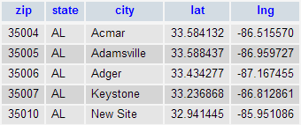
We're happy to release an open source database of US zip codes, the associated city, the state and the latitude and longitude.
Source: 2000 Census. Formatted by Simplemaps.
License: MIT (attribution appreciated)
Format: SQL and CSV
Structure:
//Replace with your database credentials
$username = "root";
$password = "";
$hostname = "localhost";

//What the user is searching for
$query = 'Minneapolis';

//connection to the database
$dbhandle = mysql_connect($hostname, $username, $password)
  or die("Unable to connect to MySQL");
echo "";
$selected = mysql_select_db("us_cities",$dbhandle)
  or die("Could not select excel");
$query=mysql_real_escape_string($query);


//Query mysql database
$sql = "SELECT * FROM  `zips` WHERE  `city` LIKE  '%".$query."%'LIMIT 0 , 10";
$result = mysql_query($sql);

//Create array of cities
$i=0;
$cities=array();
while ($row = mysql_fetch_array($result)) {
    $cities[$i]=$row{'city'}.", ".$row{'state'};
    $i++;
}

//Make sure they are unique
$out =array_unique($cities);

//The final array
var_dump($out);
function getDistanceFromLatLonInKm(lat1,lon1,lat2,lon2) {
  var R = 6371; // Radius of the earth in km
  var dLat = deg2rad(lat2-lat1);  // deg2rad below
  var dLon = deg2rad(lon2-lon1);
  var a =
    Math.sin(dLat/2) * Math.sin(dLat/2) +
    Math.cos(deg2rad(lat1)) * Math.cos(deg2rad(lat2)) *
    Math.sin(dLon/2) * Math.sin(dLon/2);
  var c = 2 * Math.atan2(Math.sqrt(a), Math.sqrt(1-a));
  var d = R * c; // Distance in km
  return d;
}

function deg2rad(deg) {
  return deg * (Math.PI/180)
}
© Simplemaps.com 2010-2015 | License | Privacy Policy | Releases | Testimonials | Resources | Documentation
Deprecated Maps: Flash USA Map | Flash World Map | Flash Canada Map | Flash Europe Map | Flash Congress Map
Formerly FlashUSAmap.com and Flashworldmap.com