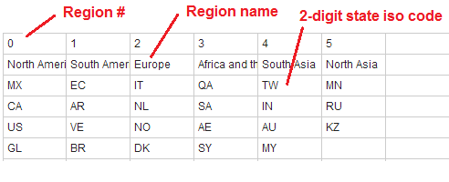
Regions make it possible to group states together. In the world map, regions are defined by default to allow continent-level zooming. In the US map, regions are undefined by default. It is possible to create and customize regions using our online customization tools.
| Properties (add these manually to the regions object in the mapdata.js file) | |
|---|---|
| name | The name of the region |
| description | The description for the the region. It can contain HTML and CSS. |
| states | The list of 2-digit state iso codes in each region generated by the customization tool. Do not change these manually. |
| color | The color for all of the states in the region. If it exists, it will overwrite any state/level colors. |
| hover_color | The hover_color for all of the states in the region. If it exists, it will overwrite any state/level hover_colors. |
| url | The url to go to when the region is clicked. If it exists, it will disable zooming on the particular continent. |
© Simplemaps.com 2010-2015 | License | Privacy Policy | Releases | Testimonials | Resources | Documentation
Deprecated Maps: Flash USA Map | Flash World Map | Flash Canada Map | Flash Europe Map | Flash Congress Map
Formerly FlashUSAmap.com and Flashworldmap.com